Home : Destinations : Photo Gallery : Maps
Home > Maps > Windward and Leeward Islands
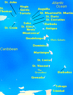
Windward and Leeward Islands - Map
The Windward Islands are the southern group of the Lesser Antilles in the West Indies, curving generally southward for about 300 miles (480 km) from the Leeward Islands towards NE Venezuela.The Windward Islands consist of the French island of Martinique and the former British Windward Islands). The former British islands consist of the independent states of Dominica, Grenada, St. Lucia, and St. Vincent and the Grenadines. Barbados and Trinidad and Tobago are in the region but are not part of the Windward Islands. The Leeward Islands are the northern group of the Lesser Antilles extending SE from Puerto Rico to the Windward Islands. The principal islands are the United States Virgin Islands, the French island of Guadeloupe and its dependencies, the Dutch Antilles islands of St. Eustatius and Saba, Dutch Sint Maarten and French St. Martin, the islands of St. Kitts and Nevis and Antigua and Barbuda, and the islands of the British dependent territories of Anguilla, Montserrat, and the British Virgin Islands. Click here for the latest hurricane news.
About Us : Advertise with Us : Disclaimer : Privacy Policy : Contact Us © 1995-2006 Turquoise Interactive. All rights reserved..